An AI framework for Change Analysis and Forecast Modelling of Temporal Series of Satellite Images
Article Sidebar
Main Article Content
Abstract
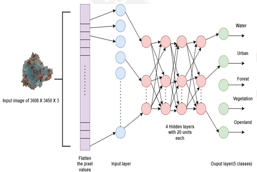
The study focuses on change analysis and predicting future LULC map of capital city of Karnataka state, India. The chosen study area is more prone to urbanisation and greatly affected by population in recent years. Spatial-temporal data from 1989-2019 are considered. LULC classes comprise of Water bodies, Urban, Forest, Vegetation and Openland. An optimal LULC maps from 1989 to 2019 obtained by deep neural network technique are used to perform change analysis which would mainly give the change LULC map with number and percentage of change pixels. According to the analysis performed major change as environmental affecting factor was noticed between 2009 and 2019 where in urban with the area of 189.3861 sq. km remain unchanged and noticeable transitions from other LULC classes to urban. Later, time series classification was performed using Cellular Automata, Cellular Automata-Neural Networks, techniques to predict the LULC map of 2024. Among these CA-NN outperformed with an average kappa coefficient of 0.83. Also, this was validated with projected LULC map of 2024 provided by USGS.
Article Details
References
Sandeep, Kaur. "The effect of urbanisation on environment in India." Int J EmergTechnol 8, no. 1 (2017): 122-126.
Droj, Gabriela. "GIS and remote sensing in environmental management." J Environ Prot Ecol 13, no. 1 (2012): 361.
Rahman, Atiqur, Yogesh Kumar, Shahab Fazal, and Sunil Bhaskaran. "Urbanization and quality of urban environment using remote sensing and GIS techniques in East Delhi-India." Journal of Geographic Information System 3, no. 01 (2011): 62.
Ghauri, D., and Arjumand Zaidi. "Application of remote sensing in environmental studies." Aerosp Sci Eng 1 (2015): 1-8.
Sharma, Abhay, and Abha Sharma. "Remote sensing: A tool for sustainable environment." Journal of Pharmacognosy and Phytochemistry 8, no. 1 (2019): 1270-1276.
Cohen, Warren B., and Samuel N. Goward. "Landsat's role in ecological applications of remote sensing." Bioscience 54, no. 6 (2004): 535-545.
Kaul, Harshika A., and Ingle Sopan. "Land use land cover classification and change detection using high resolution temporal satellite data." J. Environ 1, no. 4 (2012): 146-152.
Yu, Haiying, P. K. Joshi, K. K. Das, D. D. Chauniyal, DAVID R. Melick, X. U. E. F. E. I. Yang, and J. Xu. "Land use/cover change and environmental vulnerability analysis in Birahi Ganga sub-watershed of the Garhwal Himalaya, India." Tropical Ecology 48, no. 2 (2007): 241.
Tripathy, Pratyush, and Amit Kumar. "Monitoring and modelling spatio-temporal urban growth of Delhi using Cellular Automata and geoinformatics." Cities 90 (2019): 52-63.
Kumar, Amit. "Analysing urban sprawl and land consumption patterns in major capital cities in the Himalayan region using geoinformatics." Applied Geography 89 (2017): 112-123.
Banzhaf, Ellen, Volker Grescho, and Annegret Kindler. "Monitoring urban to peri?urban development with integrated remote sensing and GIS information: a Leipzig, Germany case study." International Journal of Remote Sensing 30, no. 7 (2009): 1675-1696.
Gharaibeh, A., A. Shaamala, R. Obeidat, and S. Al-Kofahi. "Improving land-use change modeling by integrating ANN with Cellular Automata-Markov Chain model. Heliyon, 6 (9), e05092." (2020).
Aburas, Maher Milad, Mohd Sanusi S. Ahamad, and Najat Qader Omar. "Spatio-temporal simulation and prediction of land-use change using conventional and machine learning models: a review." Environmental monitoring and assessment 191, no. 4 (2019): 1-28.
Ramachandra, T. V., and Bharath H. Aithal. "Wetlands: Kidneys of Bangalore’s landscape." National Wetlands Newsletter 37, no. 1 (2015): 12-16.
Pallavi M, Thivakaran T K and Chandankeri Ganapathi, “Evaluation of Land Use/Land Cover Classification based on Different Bands of Sentinel-2 Satellite Imagery using Neural Networks” International Journal of Advanced Computer Science and Applications(IJACSA), 13(10), 2022. http://dx.doi.org/10.14569/IJACSA.2022.0131070.
Street, Maria E., Massimo Buscema, Arianna Smerieri, Luisa Montanini, and Enzo Grossi. "Artificial Neural Networks, and Evolutionary Algorithms as a systems biology approach to a data-base on fetal growth restriction." Progress in Biophysics and Molecular Biology 113, no. 3 (2013): 433-438.
Liu, Yan, and Stuart R. Phinn. "Modelling urban development with cellular automata incorporating fuzzy-set approaches." Computers, Environment and Urban Systems 27, no. 6 (2003): 637-658.
Mokarram, Marzieh, and Tam Minh Pham. "CA-Markov model application to predict crop yield using remote sensing indices." Ecological Indicators 139 (2022): 108952.
Wang, Shi Qing, X. Q. Zheng, and X. B. Zang. "Accuracy assessments of land use change simulation based on Markov-cellular automata model." Procedia Environmental Sciences 13 (2012): 1238-1245.
Sang, Lingling, Chao Zhang, Jianyu Yang, Dehai Zhu, and Wenju Yun. "Simulation of land use spatial pattern of towns and villages based on CA–Markov model." Mathematical and Computer Modelling 54, no. 3-4 (2011): 938-943.
Aithal, Bharath H., S. Vinay, and T. V. Ramachandra. "Prediction of land use dynamics in the rapidly urbanising landscape using land change modeller." In Int. Conf. Adv. Comput. Sci, pp. 13-14. 2013.
Asadi, Milad, Amir Oshnooei-Nooshabadi, Samira-Sadat Saleh, Fattaneh Habibnezhad, Sonia Sarafraz-Asbagh, and John Lodewijk Van Genderen. "Urban Sprawl Simulation Mapping of Urmia (Iran) by Comparison of Cellular Automata–Markov Chain and Artificial Neural Network (ANN) Modeling Approach." Sustainability 14, no. 23 (2022): 15625.
McHugh, Mary L. "Interrater reliability: the kappa statistic." Biochemia medica 22, no. 3 (2012): 276-282.
Krygier, John, and Denis Wood. Making maps: a visual guide to map design for GIS. Guilford Publications, 2016.
Pallavi, M., T. K. Thivakaran, and Chandankeri Ganapathi. "A Tile-Based Approach for the LULC Classification of Sentinel Image Using Deep Learning Techniques." In 2022 International Conference for Advancement in Technology (ICONAT), pp. 1-5. IEEE, 2022.
Dittrich, Christoph. "Bangalore: Globalisation and fragmentation in India’s hightech-capital." Asien 103, no. 3 (2007): 45-58.
Emmert-Streib, Frank, Zhen Yang, Han Feng, Shailesh Tripathi, and Matthias Dehmer. "An introductory review of deep learning for prediction models with big data." Frontiers in Artificial Intelligence 3 (2020): 4.
Sekertekin, A., A. M. Marangoz, and H. Akcin. "Pixel-based classification analysis of land use land cover using Sentinel-2 and Landsat-8 data." Int. Arch. Photogramm. Remote Sens. Spat. Inf. Sci 42 (2017): 91-93.