Modelling Accessibility based on Urbanization using Artificial Neural Networks (ANN)
Article Sidebar
Main Article Content
Abstract
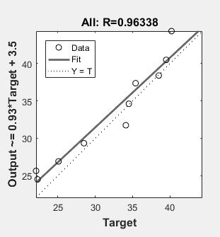
The present study involves modelling the accessibility index with respect to the traffic volume, Right of Way width and Population density. It also involves the collection of number of different types of opportunities like schools, hospitals, ATMs, bus-stops and parks to determine the accessibility index. Two different methods are used in the study such as Multiple Linear Regression (MLR) and Artificial Neural Networks (ANN) to develop models in order to predict the accessibility index. Based on the R2 value obtained in the models, it is observed that ANN has better prediction capability than MLR model. The study acts as a guide to the urban transportation planners to understand the change in accessibility index when there is a change in urbanization variables.
Article Details
References
Hauer, E., Kononov, J., Allery, B. and Griffith, M (2002). Screening the Road Network for Cites with Promise. Transportation Research Record, (1401): 17–25.
Lohse, D. (1997). Grundlagen der Straßenverkehrstechnik und der Verkehrsplanung, Band 2: Verkehrsplanung, 2. Aufgabe, Berlin, izdatelstvo. BauwesenGMbH: 326 p.
Lukanin, V.N., Buslaev, A.P., Trofimenko, Yu.W., Yashina M.V. (1998). Modeling and Optimal Control of Transport Flows in Megapolis. International Journal of Vehicle design, (3).
Maslov, A. (1970). Motivation and Personality. Rev. ed. Harper and Row, New York. Ortuzar, J.D., Willumsen, L.G. (2001). Modeling Transport. John Wiley & Sons Ltd, 594 p.
Kumar Pandey, A. . ., Arivazhagan , D. ., Rane , S. ., M. Yadav , S. ., Nabilal , K. V. ., & Oberoi , A. . (2023). A Novel Digital Mark CP-ABE Access Control Scheme for Public Secure Efficient Cloud Storage Technique. International Journal of Intelligent Systems and Applications in Engineering, 11(3s), 100–103. Retrieved from https://ijisae.org/index.php/IJISAE/article/view/2536
Taha H.A., (1997). Operations Research: an Introduction. Prentice Hall International.
Trofimenko, Yu.V., Yakimov, M.R. (2013). Transport Planning: Moulding of Efficient Transport Systems in Large Cities. ?oscow: Logos, 464 p.
Yakimov M.R. (2013). Transport Planning: Development of City Transport Model. ?oscow: Logos.
Jackson, J.H; ?Migration and Urbanization in Ruhr Valley, 1821-1914‘, Humanities Press, New Jersey, 1997
Pandey, Pradyumna: Impact of Industrialization on Urban Growth: A Case Study of ChotaNagpur‘, Allahabad Central Book Depot, 1970. 48.
Prasad, M: Social Aspects of the mining Towns of the Tribal Region‘, Part I, New Delhi, 1986.
Prasad N.; Determination of Stage of Landscape Evolution Through Relief Measures, Facets of Geomorphology (Edited by A. Kumar), 1985.
Raj, Hans; Fundamentals of Demography‘; Surjeet Publications, Delhi, 1998. 51. Ram, L. N.; ?A Systematic Geography of Bihar‘, Geographical Society, Patna, 1991.
Ramachandran, R.; Urbanization and Urban Systems in India‘, Oxford University Press, India, 1989. 53. Reissman, L.; The Urban Process, New York, 1964.
Sahu, Shukdeo; Evolution of Terrain for Agricultural Land-use in the Ajay Basin, Bihar, (A Study in Environmental Geomorphology), 1997.
Mr. Bhushan Bandre, Ms. Rashmi Khalatkar. (2015). Impact of Data Mining Technique in Education Institutions. International Journal of New Practices in Management and Engineering, 4(02), 01 - 07. Retrieved from http://ijnpme.org/index.php/IJNPME/article/view/35
Saxena, H.M.; Environmental Geography‘, Rawat Publications, 1991, New Delhi, pp.87-89.
R. Manonmani, S. Prabaharan, M. Ramalingam (2018), “Application of GIS in urban utility mapping using image processing techniques”, Geo-spatial Information Science, Volume 15, Issue 4
Sarath K. Guttikunda& Ramani V. Kopakka (2014), “Source emissions and health impacts of urban air pollution in Hyderabad, India”, Air Qual Atmos Health, 7:195–20
Kurre Sai Sahitya, C. S. R. K. Prasad (2020), “Modelling structural interdependent parameters of an urban road network using GIS”, Spatial Information Research, volume 28, pages: 327–334
Mohammed Akhter Ali (2017), “Remote Sensing &Gis A Tool For Urban Studies- Amenity Patterns In Hyderabad (A.P, INDIA).”, City Planning Review,202, 64–72
Bhupendra Singh, Ankit Gupta (2015), “Recent trends in intelligent transportation systems: a review” Research Directory • J. Transp. Lit. 9 (2)
Thakre, B., Thakre, R., Timande, S., & Sarangpure, V. (2021). An Efficient Data Mining Based Automated Learning Model to Predict Heart Diseases. Machine Learning Applications in Engineering Education and Management, 1(2), 27–33. Retrieved from http://yashikajournals.com/index.php/mlaeem/article/view/17
Miller, J., Evans, A., Martinez, J., Perez, A., & Silva, D. Predictive Maintenance in Engineering Facilities: A Machine Learning Approach. Kuwait Journal of Machine Learning, 1(2). Retrieved from http://kuwaitjournals.com/index.php/kjml/article/view/113
Peng, Z. R. (1997). A Methodology for Design of a Gis-Based Automatic Transit Traveler Information System. Comput., Environ. and Urban Systems, 21(5), 359-372.
Kumar, P., Singh, V., & Reddy, D., (1999). Advanced Traveler Information System for Hyderabad City. IEEE Transactions on Intelligent Transportation Systems, 6(1), 26-37.
Hasnat, M. A., Haque, M. M., & Khan M. (2006). GIS Based Real Time Traveler Information System: An Efficient Approach to Minimize Travel Time Using Available Media, available from www.bracu.ac.bd.
Zhang, J., Liaoa, F., Arentzea, T., &Timmermansaa H. (2011). A Multimodal Transport Network Model for Advanced Traveler Information Systems. Procedia Computer Science, 5, 912-919.