Prediction of Housing Price and Forest Cover Using Mosaics with Uncertain Satellite Imagery
Article Sidebar
Main Article Content
Abstract
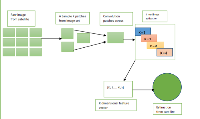
The growing world is more expensive to estimate land use, road length, and forest cover using a plant-scaled ground monitoring system. Satellite imaging contains a significant amount of detailed uncertain information. Combining this with machine learning aids in the organization of these data and the estimation of each variable separately. The resources necessary to deploy Machine learning technologies for Remote sensing images, on the other hand, restrict their reach ability and application. Based on satellite observations which are notably underutilised in impoverished nations, while practical competence to implement SIML might be restricted. Encoded forms of images are shared across tasks, and they will be calculated and sent to an infinite number of researchers who can achieve top-tier SIML performance by training a regression analysis onto the actual data. By separating the duties, the proposed SIML solution, MOSAIKS, shapes SIML approachable and global. A Featurization stage turns remote sensing data into concise vector representations, and a regression step makes it possible to learn the correlations which are specific to its particular task which link the obtained characteristics to the set of uncertain data.